Thunder Canyon was the first of the impressive Carmarthen canyons to be discovered. It was first descended in 1960 by an SUBW party of Colin Oloman, Gerry O'Byrne and Dick Donaghey, as part of a trip from Mt Charles on the Bell Road to Leura. The discovery gave a major boost to the exploration of sandstone canyons in the Blue Mountains.
Thunder Canyon tends to be overshadowed by its tributaries Claustral and Ranon as access is more difficult, and the best part of the canyon can be visited from the bottom.
Entry
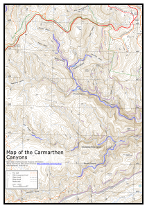
Leave a car at the Claustral car park at MGA583847 just past Mt Bell. Walk (or drive) 2.5km west along Bells Line of Rd to Mt Charles. If you are driving, there is an open area on the right hand side just after the top of the hill to park at, though visibility is poor. A better option may be to park earlier on the at MGA568845, near the 888 point, where the visibility is better. Either way, walk to Mt Charles.
Navigate carefully along Lightning Ridge to near the end where it starts to drop steeply. Make your way down to the south and east to a significant cliffline. Entry into the creek will usually require one or two abseils, up to 25m - some scouting around may be needed to find appropriate spots, as the cliff is quite high in places. Around MGA585825 there is a ramp that may get you fairly close to the creek. Otherwise near the southern point.
A better approach may be to enter the creek higher up, around the creek junction at MGA577830. This avoids some of the scrub on the ridge, but may still require an abseil, and adds a kilometre of creek walking. It also allows the first canyon section mentioned below to be passed through.
Notes
Depending on where you come in, there is a nice upper section of canyon between MGA584824 and MGA585824
The main canyon section starts downstream at MGA586825. There are a few options for the abseils. A good option is 20m from a tree down the falls to the left, and then 8m down the next section. The first person should check that the crack to the right is not blocked before pulling ropes. Alternatively scramble down the gully to the right (rope may be needed) and do about 20m from a tree.
There is a superb section of high narrow canyon from here to the Claustral junction, about 300m long.
The creek opens out for about 500m before narrowing again. There are some tricky climb downs as you drop into this canyon section, but abseiling can be avoided by finding the right route. Then there is a 7m abseil from bolts high on the right. Immediately after this is the Tunnel Swim, which can sometimes be a wade, but is usually a long cold swim up to 50m through a dark tunnel. The next drop can be climbed down on the left in low water, but is dangerous in high water, and should be abseiled on the right hand side in those conditions.
About 50m past the climb down, Rainbow Ravine is a reasonably obvious sloping waterfall that comes in on your left, as the creek bends right. A further 50m past this there is a final 20m swim to the exit gully. Many parties miss this exit and end up being benighted in the canyon, so be careful.
Exit
Scramble up the exit gully for about 20m and then traverse left under the cliff to Rainbow Ravine. Do not continue up the initial exit gully, as it becomes steeper and more dangerous. A yellow and black sign points the way to stop you going too far up. Follow narrow ledges around to Rainbow Ravine and head upstream. There are a few tricky scrambles, and some wades (for those who carry dry socks or shoes).
Where the gully splits higher up, head up the left branch. At the waterfall at the top, walk to the right along the ledge under a small cliffline to the other gully until you get near the creek, and then up a ramp to the left and back over the top to the left gully.
The old route used to continue straight up the left gully via a couple of scrambles, but this is discouraged due to erosion above the waterfall.
From there follow the obvious track up to the Camels Hump. Head down and right to the Camels Saddle, ignoring tracks off to the left, and then up a short way to the next minor saddle at MGA597834. Turn left here, and follow the track steeply downhill until you reach Claustral Brook. There are metal signs pointing the way at two points.
A track can be followed alongside the creek for some way. There are a couple of scrambles and wades before Dismal Dingle comes in on the right. Past the junction with Dismal Dingle, there are a couple of canyon sections, which may involve short swims - though skilled canyoners may avoid these by judicious scrambling and bridging. Shortly after the last of these you reach the exit gully on the right at MGA589837.
An alternate route leaves from the Camels Hump to the end of the ridge at MGA589837, from where 1-2 abseils are required to get back into Claustral Brook just opposite the entry/exit gully. Some routefinding is required.
Head up this gully until you reach the constructed track, and follow this back to your car.
Comments
- Difficulty: M
- Abseils: 1-5
- Longest abseil: 20m
- Quality: 8/10
- Time: 9-11 hours
- Distance: 12km
- Ascent: 510m
- Wetsuits: Recommended
- Maps: 8930-1N Mount Wilson
The canyon is very good but is not that long given the walk in. It is worth going up Claustral some way to have a look at the main canyon section there.
There are a few short swims in Thunder, depending on sand movement. There are about three longer swims in Thunder Gorge below the Claustral junction, including the Tunnel Swim.
The exit is also quite long. It is likely to take most parties between 3 and 4 hours from near Rainbow Ravine back to their car.