Most parties just visit the lower canyon section of Bowens Creek North Branch. While the lower section is the best, there are also good canyon sections in the upper part of the creek. A good long day trip starts high in the headwaters and continues to the junction with the South Branch.
Entry
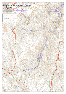
Leave a car near the start of the fire trail on the left as you drive out along Wynnes Lookout Rd, at Mt Wilson at MGA559883 (Mt Wilson map). Drive the other car to the bottom of the main hill before Mt Wilson, at about MGA551885. Head ESE into the creek. The creek slowly becomes canyoniferous before you finally reach a section of canyon.
Notes
There are about 5 sections of canyon in the creek before you reach the junction with the South Branch.
A couple of these are in the first couple of kilometres. The creek walking between these sections is pleasant and relatively easy. There are a couple of drops in these sections where a 10m hand line is useful, and there are a reasonable number of other scrambles and climb downs. If you are prepared to swim there is a bit less scrambling. There are a number of deep wades, but the swims can largely be avoided.
The creek then opens out into a scrubby section, before another short section of canyon, followed by some more easy creek walking and then a hand-over-hand or possible jump to start another section of canyon around MGA566868. There may be a couple of swims here. Then there is a considerable walk to get to the final section of canyon. The creek begins to drop more sharply and there are quite a number of scrambles down bouldery sections, which takes additional time.
There are a couple of drops in the creek before the main canyon starts. Good route finding can avoid the need for a rope. The second can be avoided by traversing right and climbing down a tree, although there are a couple of sets of tapes. It can also be jumped - check the depth first.
The first actual abseil is from ropes around a bollard on a slippery ledge up to the right. It is a little tricky to get to the anchor. A safety line is advisable. The abseil is about 12m into the water, or about 8m to a ledge from where you could jump. Alternatively, abseil about 8m directly down the waterfall. The second abseil is about 12m from tapes around a tree up to the right, into a pool. Some further climb downs and swims follow before this section of canyon ends at the junction with Bowens Creek South Branch.
Exit
From the junction with the South Branch, you can see a small gully coming in from the left about 50m downstream. Climb out here and follow a rough track up the gully. There may be a couple of fixed lines here on difficult sections, otherwise someone may need to scramble up and drop one down. At the bottom cliff line head left until you reach a break in the cliffs. Scramble up here. A track largely follows the ridge back up to the fire trail you walked in on at MGA580885. From here it is a 2.5km walk back to the car.
Comments
- Difficulty: M
- Abseils: 2-6
- Longest abseil: 15m
- Quality: 8/10
- Time: 7-10 hours
- Distance: 9km
- Ascent: 370m
- Wetsuits: Recommended
- Maps: 8930-1N Mount Wilson
The top section is a nice canyon, but not especially spectacular. There are a few quite narrow sections, and a couple of fun slides. The very bottom section is very good, deep, although not particularly dark or narrow, and very green. If you are running short of time, it is possible to exit to the left at various placing, including around MGA563868 or up the entry track for the lower section, at the creek junction at MGA578878. The lower section is described separately.
Jamieson's abseil lengths are misleading and possibly dangerous. Taking just a 20m rope is asking for trouble.
There are several swims up to 20m or so and some deep wades.