Koombanda Canyon is an attractive but short canyon flowing in to the Grose River from the north near Bell. It features a couple of short abseils and a couple of chilly swims.
Entry
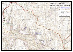
Heading west on Bells Line of Road, pull off left on a fire trail just before the road crosses the railway line. This is not marked on the map, but follows the east side of the rail line. It is generally 2wd accessible, but is a little rough in some places. Follow this for about 1.7km and park in a clearing.
Alternatively, to avoid the drive on the fire trail, it may be easier to head along Darling Causeway from Bell for 2.9km, turn left on the Canyon Colliery Trail, and park. Walk across the bridge over the railway line, and turn left on the fire trail for 1.5km to the clearing.
Contour around the south side of the hill (the 1085 point on the map) keeping north of the major tributary, and drop in to the tributary that joins the main creek at MGA473872 (Mt Wilson). There may be some scrub getting into the trib. Follow the trib down to a waterfall where it enters the main creek, and walk down an easy gully to the left of the drop. There are tapes in a tree to the right, but quite unnecessary. Head down the creek for 400m to the start of the canyon.
Notes
The first abseil is about 7m, and then there is a swim of about 20m. The second abseil is shortly after. This is up to 13m - but probably more like 8m - from a long sling from a tree high up on the right hand side into a deep dark cleft. You finish in waist deep water. There are also rocks on the ledge from which a cairn anchor could be constructed. The final drop is only about 3m, and can be abseiled or hand-over-handed. It can also be jumped if you check for rocks first. A chilly 10m swim follows, and the canyon ends shortly after.
Exit
Continue down the creek for 700m until you reach a bridge, at the old colliery. Follow the road back up the hill, with good views of the upper Grose Valley. There is one section that is tricky to negotiate, as the road has been washed away in a landslip. Just before the road crosses the railway line on a bridge, turn right and follow a dirt road back to your car (1.5km). If you had a second car you could drop it at the colliery turnoff if you wanted to save the walk, though it is hardly worth it.
Alternatively you can head up Kamarah Gully and on to Koombanda Ridge or Kamarah Ridge, and thence back to the road. If you take this exit, you could leave a second car on the Bell Rd.
- Difficulty: EM
- Abseils: 2-3
- Longest abseil: 15m
- Quality: 4/10
- Time: 4-6 hours
- Distance: 7km
- Ascent: 250m
- Wetsuits: Optional
- Maps: 8930-1N Mount Wilson