11-13/09/1999 - report - photos
Participants: Tom Brennan, Lisa McGinnigle, Fiona Macrae, Chris Stephens, Josh Nissenbaum, Owen Rogers, Melissa James
Background
The idea for this walk came from looking at all the maps and the recommended walks in the Mountain Lagoon area of the Colo River in Wollemi National Park. There seemed to be lots of good out and back walks, but there didn't seem to be a good loop walk. The Mountain Lagoon - Colo Meroo walk looked like fun, as did the Mountain Lagoon - T3 Track walk, and the Colo River looked a potential way of linking these two up to form a loop.
After talking to a few people and reading a fair bit, I was comfortable that it was lilo-able from Tootie Creek to Colo Meroo, but not necessarily walkable in the other direction. Still, I figured that by putting a couple of backup plans in place we could give it a go, and still have options if it proved impossible.
And so we accepted the challenge...
Day 1: Mountain Lagoon to Colo Meroo (12km)
We did a car shuffle before starting off and left a car down on the road at Upper Colo, just in case we weren't able to walk up the river. This took a while, as the Mountain Lagoon Fire Trail that links Upper Colo with Mountain Lagoon was a crappy road in a few places, and took us some time to negotiate.
We headed off along the fire trail and soon found some waratahs in flower alongside the track, although I wasn't 100% convinced of what they were. After a reasonable fire trail bash, the trail turned into a track and dropped onto the narrow Mailes Ridge. From the edge of the ridge there were excellent views in many places down to the Colo, and it looked like for the first half of the next days walk there would be ample sandbanks to walk on. However, we couldn't see around the big bend.
The end of the day saw a steep descent of several hundred metres to the campsite at Colo Meroo, and for a change we got into camp relatively early. If only we'd managed to get away similarly early the next day!
Day 2: Colo Meroo to Tootie Creek to Mountain Lagoon (17km)
We had thought that we could follow the 4WD trail to the west out of the Colo Meroo campsite until it ended and then start towards the river. However, the 4WD track ends in a gate to a property in about 50m, and since we didn't know the owners, we went back to the campsite, walked down the path to the beach and headed along the sandbank up the river. We quickly found a couple of the residents sitting on the beach in the sun, and chatted to them about our chances of walking up the river. One of them said he'd done it by canoe, and thought that we'd be able to walk it - except that it might take us longer than a day!
We headed off along the sandbank, and then up the left-hand bank as the sandbank quickly disappeared. After a few minutes of bush bashing, we succumbed to the inevitable. Off went the shoes and socks, and into the water we went.
The river is dotted with large sandbanks and for the first hour we spent about equal time walking alternately on them and wading in calf-deep water. A couple of times people misguessed which way to go and ended up waist-deep in the water, but mostly it was pretty easy going. There are large areas of the river bottom that are covered in quicksand. Only 6 to 12 inches deep for the most part but enough to be quite annoying when your foot never ends up where you think it should. Even on the sandbank, people were up to their knees at times in quicksand, which was amusing ... as long as you had taken a different path!
After an hour (about 3.5km) we reached the first deep section of river and we took a detour of about 200m along the sandy right-hand bank. This would have been fine except that Fiona decided she had found a better route and headed up the left-hand bank instead. The rest of us sat and waited for 20 minutes until she managed to bush bash her way along the bank to a shallower section of river.
At about the two hour mark we reached the hairpin bend in the river where it curves around to the north (5.5km). There were a few calls for a lunch stop which I resisted, muttering something about most of the walking still being ahead of us. After Owen threw Fiona into the river (no particular reason - he'd failed to throw Lisa in so he was looking for an easier target), we pressed on. The river started to get deeper, and after a further 1km we reached the first set of rapids. These were pretty tame and we were able to pass them on the left-hand bank.
The second set of rapids was not much more than 500m further ahead. We were on the right-hand bank at this point and were able to pass them without much difficulty. To get back onto the sandbank required wading through waist deep water across some rather slippery rocks, and I was happy to have a good strong stick I'd found the night before.
We could already see the third set of rapids about 500m upstream. We comfortably passed them on the left-hand side before we realised that the river was too deep here to allow us to get back to the sandbank in the middle. In hindsight, the smart move would have been to keep bush-bashing up the left-hand side until the water got shallow enough to walk in again. Hindsight is a beautiful thing!
In practice, we went back to the rapids and tried to cross. Without going into gory details, our score was: one near accident (Chris almost got sucked down one of the gaps), one dropped pack (mine), one wet pair of shoes (mine) and one lost walking stick (mine again). Luckily Chris was shaken but uninjured, and my pack only got a brief dunking so with the garbage-bagging not much got wet.
By this stage it was nearly 4pm and we were still about 1.5km from the Tootie Creek junction where we would leave the river. We were rapidly running out of time, the sun had disappeared behind the walls of the gorge, and the river was getting colder. We walked along a sandbank on the eastern side of the river for a few hundred metres, and then along the eastern bank for a few hundred more after the sandbank disappeared. At this point we had to somehow get to the western bank as that was the side that the Tootie Creek junction was on.
The shallowest section of the river here was chest-deep for most of the guys and neck-deep for two of the girls. Packs were held above our heads and we just hoped we wouldn't stumble in the current. Finally we all made it to a sandbank on the western side. It took us almost 40 mins to get to this point from the rapids, and things were looking grim timewise. I had scouted ahead a bit at this point and figured that we could walk for only a few hundred more metres along the sandbank before we would have to climb out and walk the last 500m or so along the western bank, or be stuck on the wrong side of the river.
In the end this last section was fairly easy, although there were a few isolated patches of blackberry bushes which caused some problems with the bare feet. And yes, we had walked almost the entire day in bare feet!
We reached the Tootie Creek junction just before 5pm, with about an hour of sunlight left. There was a rapid debate over what we should do here. We had a 500m ascent over 3km that would take us to the Wollemi Lookout end of the T3 Track fire trail, and we figured if we reached the lookout we could walk the rest in the dark on the fire trail without too much risk. It was really just a case of whether we should give up a good camping spot on the river bank here in favour of attempting the walk out. The main risk would be not finding a good camping spot if we failed to complete it, which seemed very likely. In the end, the vote was to press on.
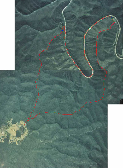
We filled up on water, headed up Tootie Creek for a short distance, and then the track turned away from the creek up the ridge to the south. The Tootie Creek Track at this point is not marked on the topographic map (nor is it particularly well marked on the ground!), and at the top of the first section of the ridge I would have to argue that the topo is incorrect. There is a knoll that does not appear on the topo (just before the second blue X on my aerial map) which fooled us for about 20mins. Of course, it could be just smaller than the 20m contour interval, but I don't believe that is the case.
Thinking it was the ridge we were supposed to follow, we climbed up on top of it, packs and all (it's a bit of a climb). We then spent the next 10 minutes looking at all the other landmarks around and convincing ourselves that we were standing on top of a topological error. At 5:45pm, with the light rapidly fading, I called a halt for the day - a bit of a problem for those of us supposed to be at work in Sydney at 9am tomorrow, but really the only safe alternative. We headed for the nearest patch of flat ground, and started setting up camp. We still had plenty of food, water and dry clothing so apart from the "late for work" factor, an extra night wasn't a problem. It certainly made me a bit more relieved when someone pointed out that we were camping on what looked like a track. I followed it for a couple of hundred metres to convince myself that it was the track we would be heading out on the next morning.
Day 3: Finishing off Day 2!
Lisa had us up and moving at the crack of dawn, and we had little trouble following the track. It came and went a few times but generally climbed along the ridge, which was pretty well defined. There were several fantastic views of the valleys to the west at a few different points on the trail, and well worth a stop and a look. We reached the Tootie Creek Track fire trail in about an hour and from there it was all pretty easy. The fire trail is fairly flat and a further hour of easy walking brought us back to the car.
Mishaps aside, a great weekend's walk and one well worth doing if you are after a challenge.
Some points to note:
- You obviously want to make sure the river is as low as possible to walk it. We didn't see any water level signs so I can't really tell you what a good height is. It was not much more than calf deep for the first 4km though.
- Start early. We didn't get away finally until 10:30am, so we were always going to be up against it to finish the walk in time.
- I'd take a stick if you have one, or find one along the way. It helps no end in the deeper and more slippery sections.
- I'd also suggest taping your feet to protect them. You could also wear shoes or sandals in the river, but it would slow you down significantly as you spend most of the time in the water. In particular, tape the sections of your feet that do not normally touch the ground (arches and the section where your toes join your feet) as those sections will not have any protective calluses (unless you spend a lot of time at the beach).
- Watch out for leeches!
- This is obviously not a winter walk. We did it early spring and it was not bad, but the weather was great. Late spring to early autumn are probably the best times.
- Stick to the river as much as possible. The bank is usually traversable, but slow.
- If you have two cars, you may want to leave one down the road at Upper Colo. If the river is not traversable upstream, that gives you a fairly easy walk out downstream (less than 8km of flat walking).
- There is nothing that says you have to camp at Colo Meroo on the first night. You could certainly head upriver a few kilometres and camp on a sandbank to get a bit of a headstart on the second day. Toilets become a problem, however, once you are on the river itself.
- The river is susceptible to change, and may not be how I have described it (particularly given that I'm doing it from memory). Sandbanks move, the river gets deeper in sections - there is no track. It is easy to get stuck for long periods of time, and you may need to backtrack to find a suitable traverse. Make sure you budget both for extra time, and extra food (if you have to do what we did and camp an extra night).
All that said, a fantastic trip, and everyone was ecstatic about us completing it, and enthusiastic about doing it or something similar again. I think the catch now is going to be finding something that they consider a challenge!