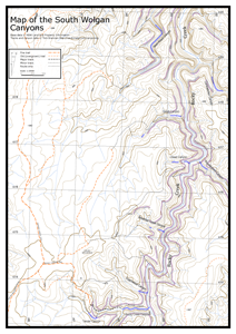
Rocky Creek Canyon is a long, dark and spectacular canyon in the South Wolgan area. It has no abseils and is thus popular with beginners.
It was discovered on a joint SUBW - UNSWBWC trip in 1976 by Dave Noble and Bob Sault. There is a short, fun upper constriction some 4km upstream, with some jumps and slides and an abseil, known as Sheep Dip Canyon, but most parties only do the lower constriction.
For a slightly longer day, start with the excellent and fun Twister Canyon, and then continue on through Rocky Creek.
Entry
See Newnes Plateau & South Wolgan Fire Trails for information on how to drive to the starting point.
From the Rocky Creek car park, continue down the main fire trail to the SE. At the end of the trail, a foot track continues down into a gully. Once at the creek, follow the track downstream for about 700m to a creek junction. There are a couple of steep sections, and you may want to take a short rope in case a fixed rope is not there. The canyon starts here at the junction.
Notes
There is a climb down a hole to start. This can also be jumped, but the pool needs to be checked as there are ledges. There are a couple more climb downs in the first section before the canyon opens out a little. There are also a number of swims in this section.
Then the main constriction starts with a slide. The main constriction is particularly spectacular, similar to Claustral and the Grand Canyon. The canyon ends at the Budgary Creek junction. There are usually a few swims, including a longish one near the end.
Exit
There are a few options to exit.
The most common is to simply reverse the canyon, although one of the climb downs can be quite difficult if there is a lot of water.
Alternatively, continue downstream for 1km to a sharp right hand bend, and climb the gully on the left. Once you break through the upper line of cliffs, climb on to the slab on the left and up the slab. This is technically easy but exposed. However, you may want to take a 30m rope to belay people if they are not confident. Follow the ridge back to the fire trail, and turn left on the fire trail to get back to the Galah Mountain Road. Turn left down the road to get back to the car park.
Also, there is a climbing exit opposite the Budgary Creek junction - you may wish to take climbing hardware for protection. Climb a slab for a few metres, and head left along the narrow ledge. At the end of the ledge, climb up (exposed) a couple of metres on to another ledge. Walk right along the ledge for 100m or so until you get to a slab. There may be a fixed rope hanging down, otherwise it is a difficult climb of about 5m up the slab. You may be able to lasso the tree. Head up the ridge through another cliff line. You may pick up a track that leads to Coachwood Canyon as you get closer to Galah Mountain. Contour around the east side of Galah Mountain to get back to the cars.
- Difficulty: E
- Abseils: No
- Longest abseil: NA
- Quality: 10/10
- Time: 3-5 hours
- Distance: 3km
- Ascent: 250m
- Wetsuits: Recommended
- Maps: 8931-2N Rock Hill
