The lower canyon section of Bowens Creek North certainly offers plenty of "bang for your buck". The walks in and out are relatively short, and the canyon section is a good length compared to many others, though it is fairly quick to traverse as the two abseils are near the beginning.
Entry
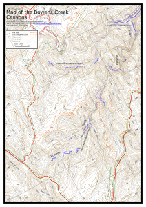
From Mt Wilson, drive out towards Wynnes Rocks, and park opposite the fire trail that branches off to the east about halfway out along the Wynnes Lookout Road (MGA559883, Mt Wilson map). Walk along the fire trail, keeping right where it forks after about 800m. Pass through a gate, pass a hill on your right, and as the next gully starts to appear, turn right 50m past a large anthill (MGA576884, signposted) and head down into the gully. There are a couple of sizeable drops in the gully that need to be skirted or sidled. Turn left at Bowens Creek and walk down the creek to the start of the canyon.
Notes
There are a couple of drops in the creek before the main canyon starts. Good route finding can avoid the need for a rope. The second can be avoided by traversing right and climbing down a tree, although there are a couple of sets of tapes. It can also be jumped - check the depth first.
The first actual abseil is from ropes around a bollard on a slippery ledge up to the right. It is a little tricky to get to the anchor. A safety line is advisable. The abseil is about 12m into the water, or about 8m to a ledge from where you could jump - check depth. Alternatively, abseil about 8m directly down the waterfall. The second abseil is about 12m from tapes around a tree up to the right, into a pool. Some further climb downs and swims follow before this section of canyon ends at the junction with Bowens Creek South Branch.
Exit
From the junction with the South Branch, you can see a small gully coming in from the left about 50m downstream. Climb out here and follow a rough track up the gully. There may be a couple of fixed lines here on difficult sections, otherwise someone may need to scramble up and drop one down. At the bottom cliff line head left until you reach a break in the cliffs. Scramble up here. A track largely follows the ridge back up to the fire trail you walked in on at MGA580885. From here it is a 2.5km walk back to the car.
Comments
- Difficulty: M
- Abseils: 2-4
- Longest abseil: 15m
- Quality: 8/10
- Time: 5-7 hours
- Distance: 8km
- Ascent: 370m
- Wetsuits: Recommended
- Maps: 8930-1N Mount Wilson
The lower section of Bowens Creek North is very good, deep, and quite spectacular. It appears to get a lot less traffic than some of the other canyons around Mt Wilson, though it is far more impressive than say Why Don't We Do It In The Road? or Waterfall of Moss.
Jamieson's abseil lengths are misleading and possibly dangerous. Taking just a 20m rope is asking for trouble.
There are several swims up to 20m or so and some deep wades.