Clatterteeth Canyon (also known as Du Faur Creek Canyon) is a tributary of Bell Creek, a little way above where that creek flows into the Wollangambe River. It has some long lilo pools. It was discovered and named by a party from Sydney Bush Walkers led by Ross Wyborn, in 1964.
Entry
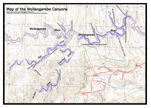
From the Fire Station at Mt Wilson, head west along the road towards Du Faurs Rocks Lookout, and turn left after about 300m through a gate marked with an arrow. Follow this fire trail for almost 2km until it heads downhill and veers left at MGA542886. Take the rough foot track that continues straight ahead. When you reach the saddle at MGA537885 (Mount Wilson), turn left and follow the track down into a creek. Continue down this creek until you reach the junction with a much larger creek (October Creek). You can usually avoid getting your feet wet until the larger creek.
At this point it may be worth putting on wetsuits. Turn right and wade downstream for about 500m to the first canyon section. This is a good spot to inflate lilos. There are a couple more long canyon sections with swims before the alternative entry below comes in.
Alternatively, turn right at the saddle and follow the track down the creek. Not far from the end scramble up right on to the ridge and do a 10m hand-over-hand from a large gum tree near the junction to regain the creek. This misses out on some very good sections of canyon, but probably saves around an hour. You may also need a 10m rope in case a fixed line is not there.
Notes
There are quite a number of canyon sections, interspersed with creek walking. The canyon sections are of good quality, but are never really sustained. The creek walking is for the most part easy and relatively scrub free, and the surrounds are delightful.
At MGA543906, Joes Canyon comes in from the right, and this can be used as an early exit. It probably saves around an hour and a half. Otherwise continue downstream past Bell Creek on the left. If you have time, the lower section of Bell Creek has good canyon sections.
About 300m after the Bell Creek junction, the creek starts to drop through boulders, and then flattens out before the junction with the Wollangambe. This flat section is slow going, as there is a fair bit of scrub, and the creek bed is covered with large slippery rocks. Bell Creek then flows into the Wollangambe River, which is easier going. About 200m after the junction, the river turns a sharp left hand bend. There is a large sandy beach on the left, and the exit track starts directly across the river.
Exit
The track heads up to the top of the saddle, and turns right, passing the turnoff to Joes Canyon after 600m. It contours round the gully on the left and then heads steadily up, reaching the main ridge, and the entry track to the Tourist Section of the Wollangambe between two pagodas. Turn right and follow the well-constructed track up the hill, crossing a fire trail, and joining another fire trail. When you reach the road, turn right, and walk back to the Fire Station where you left your car.
Comments
- Difficulty: E
- Abseils: No
- Longest abseil: NA
- Quality: 6/10
- Time: 6-10 hours
- Distance: 12km
- Ascent: 300m
- Wetsuits: Lilos
- Maps: 8930-1N Mount Wilson, 8931-2S Wollangambe
There are numerous long pools so lilos are advisable for most parties. They are, however, inconvenient in the less canyon-like sections of creek. Experienced parties may be able to do without them, but will need a full wetsuit and possibly thermals underneath. Some other flotation (eg dry bag) is also needed.