The south branch of Bowens Creek has sections of canyon from high up in its headwaters, right down to the junction with the north branch. These notes describe the most commonly visited section of Bowens Creek South Canyon, the so-called upper section (technically it's about the 4th and 5th of around 8 sections!).
Entry
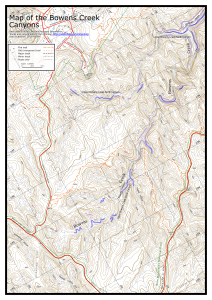
If you have two cars, and you want to avoid a 3km road walk, park one car near the start of the fire trail at Range Hill on the Bells Line of Road. There is no parking at the fire trail - so either the open area on the S side of the road about 300m E of the start of the fire trail, or the open area on the S side of the road about 600m W of the fire trail.
Then drive to Pierces Pass and park the other car at the top parking area. Walk N along the road to the top of the hill and then NE along the ridge. There is a faint pad that keeps mostly near the main ridge line. After a little over 1km the ridge starts to drop. At the pagodas there are a number of spots you can scramble to the right down into the creek. The easiest is the obvious gully you can see about 100m further on from the top of the first pagoda, getting into the creek at about MGA544843.
Notes
It is a short walk to a bit of mild canyon, shortly followed by a 14m drop. This can easily be bypassed on the right, or abseiled if you feel like it. A possible downclimb or short drop may follow, before the canyon proper is reached shortly after.
The first drop is about 9m from tapes from one of a number of trees on the right. However, it can be also be slid in two stages by climbing down under the chockstone. Both drops are usually into about waist deep water.
The anchor for the next drop is normally from tapes around a tree high up on the right. This may be up to 20m, depending on the length of the sling from the tapes, but is more likely about 15m. The junction with the main creek (Corkscrew Canyon according to Jamieson) coming in from the left is then reached. This is well worth a side trip to explore.
Continuing downstream there is a nice section of canyon, until it opens out into a lovely coachwood and sassafras forest and gorge. The junction with a side creek/canyon is soon reached (Hand-over-Hand Canyon). The creek continues to meander for some way before dropping through boulders and then into the next canyon section.
There are quite a few tricky scrambles and drops in this section. The first one is about 6m from tapes around a tree, but there are usually a couple of scrambling routes through gaps in the boulders that will get you down. Some way further downstream there is an awkward abseil of 4m (8m to the anchor) that used to be able to be slid down a log. It is possible, but tricky, to avoid this via a ledge on the right. Another drop of a couple of metres follows immediately.
It is a short walk from here to the junction with Range Creek (Hobnail Canyon). It is a good side trip to see the bottom section of Hobnail Canyon. This section of canyon finishes a little way past the junction with the next creek on the left, Ferny Cave Creek.
Exit
Continue down the creek until you reach the next tributary coming in from the left. Opposite this you will see a steep bank with ledges. There used to be logs here, but the tree propping them up is now gone post-fires. Carefully climb the bank and up the ledges. Continue this up to the next major cliff line.
Follow the cliff line around to the right for 200m to where it bends sharply left into small gully. This can be climbed through a narrow hole. Go up to the next line of cliffs and right on a track, passing a small waterfall that may have a rope hanging down. Continue around for another 120m until the cliffs break, and you can again scramble up to the next line of cliffs. These cliffs can be scrambled up to the left (easier) or the right. Follow the track up the ridge to the fire trail. Follow the fire trail back to the road, and return to where you left a second car, or otherwise walk back along Bells Line of Road to Pierces Pass (3.0km).
Comments
- Difficulty: M
- Abseils: 1-7
- Longest abseil: 20m
- Quality: 9/10
- Time: 5-10 hours
- Distance: 7km
- Ascent: 230m
- Wetsuits: Recommended
- Maps: 8930-1N Mount Wilson
Upper Bowens Creek South Canyon is an excellent canyon. The lower constriction is dark and twisting, and quite sustained. The side trips to Corkscrew Canyon and Hobnail Canyon are both worthwhile.
A 40m rope is recommended for the abseils. The abseils are relatively easy, though some parties may need to do additional abseiling as there are some drops where the route down is not obvious. If you drop off the entry ridge to the left instead of the right, it is possible to negotiate your way into Corkscrew Canyon which does not require any abseils.
The water levels are quite variable. Many years ago the canyon could be done with only waist deep wades, but presently there are numerous swims and deeper wades. Wetsuits are recommended, though experienced parties may opt to do without.